


LUMAT - Priority map – “Many small problems can lead to a big problem”
![]()
FUA Ostrava is a part of the Moravian-Silesian Region and is one of the most industrially affected regions in the Czech Republic. Historically it was mentioned as a coal and steel region. Today it is a region that is recovering from the negative impact of the transformation of heavy industry and is trying to be perceived as a SMART region. FUA Ostrava is composed of 163 municipalities and forms a significantly polycentric agglomeration.
Problems and Threats
Brownfield sites can be a source of danger to the environment due to possible seepage into groundwater.Since the 18th century, the highly industrialized region has been transformed several times and the area once used has changed to another function without thinking about potential contamination.
Site register (ContaminatedSites Database System) is not complex and can lead to the construction on land that can be dangerous.
Context
There is a Contaminated Sites Database System in the Czech Republic. This database records about 5,000 sites that are divided into three categories. The Ministry of Environment´s Guideline divides sites in categories A, P and N. The first category (A) aresites that have been already surveyed and the contamination was approved. They are divided into subgroups based on the size of the risk (simply the number of people affected by the risk).
The second category (P) are sites that can be potentially contaminated. We know that some activities were conducted on these sites in the past, but no detailed research has been carried out on what types of contaminants, at what depths and at what concentrations are located there. These areas are divided into four subgroups, with the subgroup P4 being the ones that LUMAT was interested in. The subgroup P4 is further subdivided into four hazard types.
The last category are locations N. These are those where either the survey did not show pollution, or which are already after the remediation.
Location, type of localities
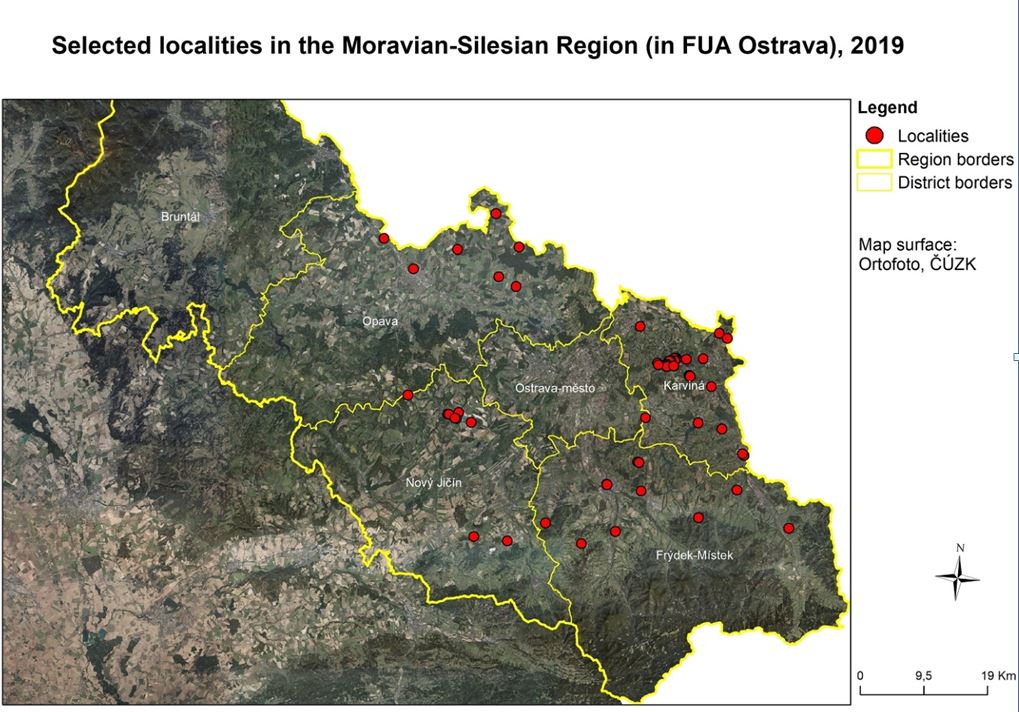
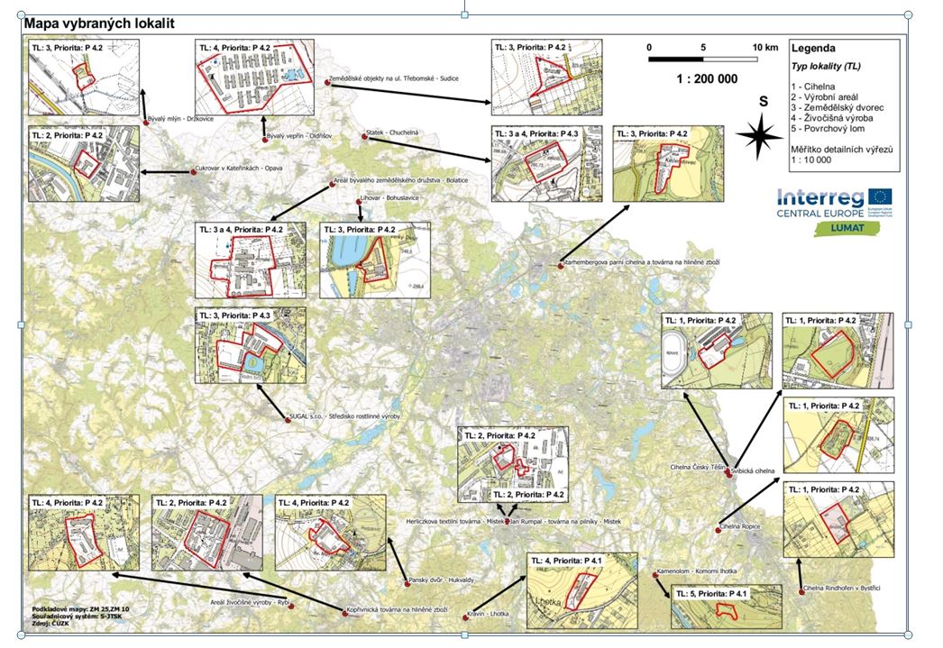
During the processing of the priority map, the research team focused on a total of 52 localities, which are located in FUA Ostrava and are not directly in the cadastral area of Ostrava. The reason for the exclusion of Ostrava was a well-developed (in 2010) comprehensive map of Priorities - these were approximately 100 localities, which were subsequently included into the Contaminated Sites Database System.
The 52 sites were selected based on several criteria to suitably demonstrate the variety and scale of the problem. The first sub-group were locations that were used as industrial sites but changed their function after World War II and now they are used for housing, services, or recreation.
The second group consists of sites that have been used for different types of use, from industry to housing and agriculture, but today the sites are completely abandoned, often overgrown. The third group are brownfield sites. None of the sites were registered in the Contaminated Sites Database System.
The location of the sites is shown in Figure 1
Problems
The first problem was the methodology of sites selection itself, often it was necessary to work with aerial photographs from the 1950s, search in chronicles. In a few cases, it was necessary to contact the owner to enter the site. Overall, the owners were rather negative. The reason was the fear of effects of the findingson the price of their land.
It was necessary to make a field survey to identify the type group of the location, to find out how the site looks like, what is the terrain morphology, what are the watercourses in the area, how many inhabitants live in the area. Furthermore, it was necessary to obtain information about the geological and hydrogeological situation of the site, about the protected areas and the limits in the area surrounding the site. Thanks to a high quality information from the INSPIRE Portal and the data from the Czech Geological Service it was possible to process properly such a number of sites.
Whatwill LUMAT do
The LUMAT project - its research team and expert company evaluated and described 52 sites in total. These sites were included in the Contaminated Sites Database System which represents an increase of more than 10% for FUA Ostrava.
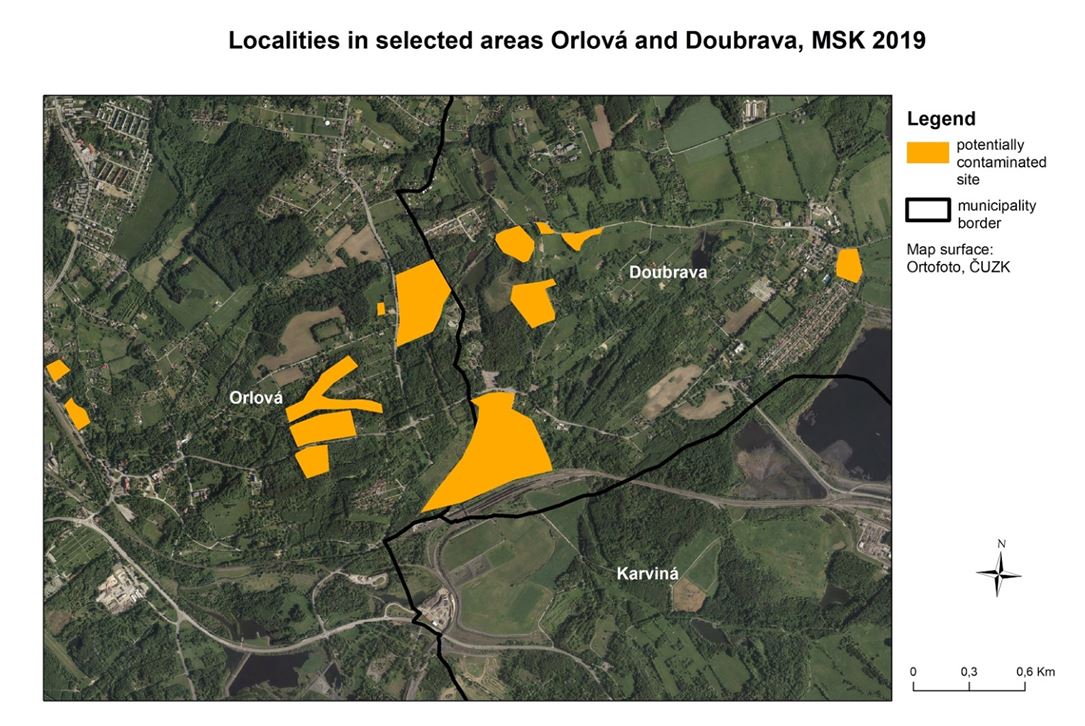
Discussion on the necessity of registering these areas was opened. Some selected municipalities have also described the extent of the problem in relation to cadaster size - see Figure 2
The map itself, whose part is shown in Figure 3, was handed over to the representatives of the region.
The success of the project can be seen in the fact that, thanks to a two-year discussion, the Ministry of the Environment was convinced to decide to register so far unregistered potentially contaminated sites in the Czech Republic and to include them in the Contaminated Sites Database System registration (it is expected to be 20,000 sites in the Czech Republic).
Stakeholders
Moravian Silesian region
Ministry of environment
Land owner
municipalities
public
Authors: Barbara Vojvodíková, Ludmila Pěgřimková, Iva Tichá

.JPG)